


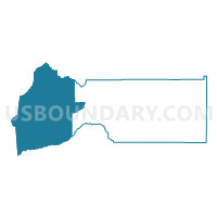
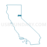
Voting District 10000, Sierra County, California
About
Outline

Summary
| Unique Area Identifier | 544293 |
| Name | Voting District 10000 |
| County | Sierra County |
| State | California |
| Area (square miles) | 323.07 |
| Land Area (square miles) | 322.76 |
| Water Area (square miles) | 0.31 |
| % of Land Area | 99.90 |
| % of Water Area | 0.10 |
| Latitude of the Internal Point | 39.56415550 |
| Longtitude of the Internal Point | -120.86879200 |
Maps

Graphs
Select a template below for downloading or customizing gragh for Voting District 10000, Sierra County, California


Neighbors
Neighoring Voting District (by Name) Neighboring Voting District on the Map
- Voting District 20000, Sierra County, CA
- Voting District 40255, Nevada County, CA
- Voting District 40295, Nevada County, CA
- Voting District 50035, Plumas County, CA
- Voting District 50050, Yuba County, CA
- Voting District 50060, Yuba County, CA
- Voting District 50305, Nevada County, CA
Top 10 Neighboring County Subdivision (by Population) Neighboring County Subdivision on the Map
- Nevada City CCD, Nevada County, CA (15,238)
- Quincy CCD, Plumas County, CA (6,661)
- Yuba Foothills CCD, Yuba County, CA (4,941)
- Graeagle CCD, Plumas County, CA (1,844)
- West Sierra CCD, Sierra County, CA (904)
Top 10 Neighboring Place (by Population) Neighboring Place on the Map
- Downieville CDP, CA (282)
- Pike CDP, CA (134)
- Goodyears Bar CDP, CA (68)
- Alleghany CDP, CA (58)
- La Porte CDP, CA (26)
- Little Grass Valley CDP, CA (2)
Top 10 Neighboring Elementary School District (by Population) Neighboring Elementary School District on the Map
- Twin Ridges Elementary School District, CA (2,544)
- Camptonville Elementary School District, CA (738)
Top 10 Neighboring Secondary School District (by Population) Neighboring Secondary School District on the Map
Top 10 Neighboring Unified School District (by Population) Neighboring Unified School District on the Map
- Marysville Joint Unified School District, CA (60,976)
- Plumas Unified School District, CA (19,367)
- Sierra-Plumas Joint Unified School District, CA (3,880)
Top 10 Neighboring State Legislative District Lower Chamber (by Population) Neighboring State Legislative District Lower Chamber on the Map
Top 10 Neighboring State Legislative District Upper Chamber (by Population) Neighboring State Legislative District Upper Chamber on the Map
Top 10 Neighboring 111th Congressional District (by Population) Neighboring 111th Congressional District on the Map
Top 10 Neighboring Census Tract (by Population) Neighboring Census Tract on the Map
- Census Tract 411, Yuba County, CA (4,941)
- Census Tract 9, Nevada County, CA (4,348)
- Census Tract 100, Sierra County, CA (3,240)
- Census Tract 2.01, Plumas County, CA (1,844)
- Census Tract 2.02, Plumas County, CA (1,161)
Top 10 Neighboring 5-Digit ZIP Code Tabulation Area (by Population) Neighboring 5-Digit ZIP Code Tabulation Area on the Map
- 95959, CA (17,838)
- 96103, CA (1,725)
- 95960, CA (796)
- 95922, CA (687)
- 95936, CA (352)
- 96125, CA (258)
- 95981, CA (97)
- 95910, CA (86)
- 95944, CA (46)